
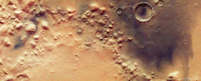
This jumble of eroded blocks lies along the distinctive boundary between the Red Planet’s southern highlands and the northern lowlands, with remnants of ancient glaciers flowing around them.
This boundary is one of the oldest and most prominent features on Mars, marking a height difference of several kilometres.
The scene presented here, captured by the high-resolution camera on ESA’s Mars Express on 29 May, is just one example of the terrain found along this ancient boundary, and focuses on part of the Colles Nili region.
‘Colles’ comes from the Latin word for ‘hill’, and indeed this region hosts a swath of such features. They are likely erosional remnants of a former plateau, as suggested with their similarity in height seen in the topography map.
Zooming in to the main colour image and perspective views shows that some of the mounds are surrounded by smooth, layered deposits gently sloping away from the sides of the hills.
An even closer look reveals other finer features on the channel floors around the mounds and inside some of the impact craters: series of ridges and troughs.
Both the layered deposits and the ridges and troughs are thought to be associated with buried ice that has since been covered over by wind-blown dust and local debris from the eroding plateau, perhaps as an underlying ice sheet retreated.

Similar features are found all along the planet-wide boundary and are thought to represent multiple episodes of glaciation within the past several hundred million years.
Later, volcanic dust has blown in from elsewhere to create the striking streaks of dark material seen in various spots, but particularly dominant in the right-hand side of the main colour image.
Looking inside the large impact crater seen in the top right of the main image, and also in the top left of the perspective view, shows this dark material has been piled up into dunes inside the crater, presumably by prevailing winds.

Mars Express has been orbiting the Red Planet since 2003. Next week it will play an important role in listening for signals from Schiaparelli, the ExoMars entry, descent and landing demonstrator, as the lander makes its six-minute descent through the atmosphere to the surface.
Mars Express, Schiaparelli mothership Trace Gas Orbiter and NASA’s Mars Reconnaissance Orbiter will record signals from Schiaparelli to confirm its safe arrival, and they will subsequently act as data relays from the surface.

Source: Phys.org


Leave a Comment
You must be logged in to post a comment.