
NASA’s New Horizons team has released the first official global mosaic and topographic maps of the dwarf planet Pluto and its largest moon, Charon.
These new maps of Pluto and Charon were produced painstakingly over a two-year period as data were slowly transmitted to Earth from New Horizons.
The quality of geographically and topographically accurate maps improved with each new batch of images that were returned to Earth.
To create the maps, Lunar and Planetary Institute researcher Paul Schenk and colleagues registered all the images from New Horizons’ Long Range Reconnaissance Imager (LORRI) and Multispectral Visible Imaging Camera (MVIC) instruments together and assembled the mosaics.
Digital analysis of stereo images obtained by both cameras were used to create topographic maps for each region; these were then assembled into integrated topographic maps for each body.
The validated maps reveal a rich variety of landforms on both Pluto and Charon and show the best resolution for each area illuminated by the Sun, and their elevations.

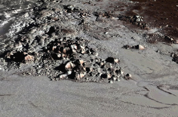
Global image mosaic of Pluto. Image credit: Schenk et al, doi: 10.1016/j.icarus.2018.06.008.
The topographic maps confirm that the highest known mountains on Pluto are the Tenzing Montes range, which formed along the southwestern margins of the frozen nitrogen ice sheet of Sputnik Planitia.
These steep-sided icy peaks have slopes of 40 degrees or more and rise several miles above the floor of Sputnik Planitia. The highest peak rises 3.7 miles (6 km) above the base of the range.
Pluto’s mountains must be composed of stiff water ice in order to maintain their heights, as the more volatile ices observed on the dwarf planet, including methane and nitrogen ice, would be too weak and the mountains would collapse.
The topographic maps also reveal large-scale features that are not obvious in the global mosaic map.
The ice sheet within the 625-mile (1,000 km) wide Sputnik Planitia is on average 1.5 miles (2.5 km) deep while the outer edges of the ice sheet lie an even deeper 2.2. miles (3.5 km) below Pluto’s mean elevation.
While most of the ice sheet is relatively flat, these outer edges of Sputnik Planitia are the lowest known areas on Pluto, all features that are evident only in the stereo images and elevation maps.
The topographic maps also reveal the existence of a global-scale deeply eroded ridge-and-trough system more than 2,000 miles (3,000 km) long, trending from north-to-south near the western edge of Sputnik Planitia. This feature is the longest known on Pluto and indicates that extensive fracturing occurred in the distant past.

Global image mosaic of Charon. Image credit: Schenk et al, doi: 10.1016/j.icarus.2018.06.010.
On Charon the topographic maps also reveal deep depressions near the north pole that are 8.7 miles (14 km) deep.
The equatorial troughs that form the boundary between the northern and southern plains on Charon also feature high relief of 5 miles (8 km).
The mapping of fractured northern terrains and tilted crustal blocks along this boundary could be due to cryovolcanic resurfacing, perhaps triggered by the foundering of large crustal blocks into the deep interior of Charon.
The rugged relief also indicates that Charon retains much of its original topography caused by its history of fracturing and surface disruption.
The new maps of Pluto and Charon and the process of creating them are described in two papers published in the journal Icarus.
Source: Sci News


Leave a Comment
You must be logged in to post a comment.